
Make a donation
Gear up for your next adventure:
As an Amazon Associate, this site earns from qualifying purchases at no extra cost to you.
Priest River topographic map
Click on the map to display elevation.
Make a donation
Gear up for your next adventure:
As an Amazon Associate, this site earns from qualifying purchases at no extra cost to you.
Priest River
Priest River is located at 48°11′0″N 116°54′34″W / 48.18333°N 116.90944°W / 48.18333; -116.90944 (48.183388, -116.909555), at an elevation of 2,139 feet (652 m) above sea level.
Make a donation
Gear up for your next adventure:
As an Amazon Associate, this site earns from qualifying purchases at no extra cost to you.
About this map
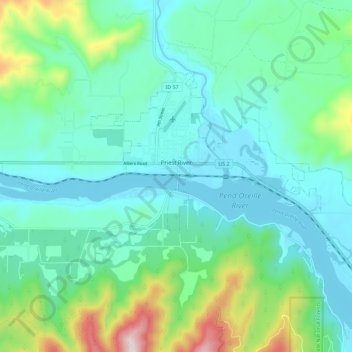
Name: Priest River topographic map, elevation, terrain.
Location: Priest River, Bonner County, Idaho, United States (48.15520 -116.93702 48.20030 -116.82294)
Average elevation: 742 m
Minimum elevation: 624 m
Maximum elevation: 1,171 m
Make a donation
Gear up for your next adventure:
As an Amazon Associate, this site earns from qualifying purchases at no extra cost to you.
Other topographic maps
Click on a map to view its topography, its elevation and its terrain.
Make a donation
Gear up for your next adventure:
As an Amazon Associate, this site earns from qualifying purchases at no extra cost to you.
Make a donation
Gear up for your next adventure:
As an Amazon Associate, this site earns from qualifying purchases at no extra cost to you.