
Apollo Beach topographic map
Click on the map to display elevation.
Apollo Beach
The history of Apollo Beach started in 1923 on land owned by the Dickman family, then used annually for farming and grazing pasture. Much of the land was mangrove and low-elevation and was considered uninhabitable.
About this map
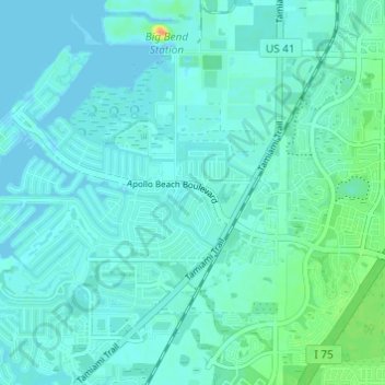
Name: Apollo Beach topographic map, elevation, terrain.
Average elevation: 6 m
Minimum elevation: -3 m
Maximum elevation: 35 m
Other topographic maps
Click on a map to view its topography, its elevation and its terrain.
Lutz
United States > Florida > Hillsborough County > Tampa
Lutz is characterized by a gently rolling topography that showcases the distinctive features of the central Florida landscape. The area has an average elevation of about 70 feet (21 meters) above sea level, contributing to its mild undulations rather than dramatic elevation changes. The terrain is marked by a…
Average elevation: 20 m
Arbors at Freedom Plaza
United States > Florida > Hillsborough County > Sun City Center
Average elevation: 15 m
Carrollwood
United States > Florida > Hillsborough County > Tampa
Carrollwood is located at 28.1 degrees north, 82.5 degrees west (28.0523, -82.4858). The elevation for the community is 39 feet (12 m) above sea level.
Average elevation: 16 m
The Reserve of Old Tampa Bay
United States > Florida > Hillsborough County > Town 'n' Country
Average elevation: 3 m
Hillsborough Heights East
United States > Florida > Hillsborough County > Tampa
Average elevation: 18 m
Keystone Park
United States > Florida > Hillsborough County > Keystone > Keystone Terrace
Average elevation: 17 m
The Borghese Villas at Westshore
United States > Florida > Hillsborough County > Tampa
Average elevation: 9 m
Carrollwood
United States > Florida > Hillsborough County
Carrollwood is located at 28.1 degrees north, 82.5 degrees west (28.0523, -82.4858). The elevation for the community is 39 feet (12 m) above sea level.
Average elevation: 16 m
Kings Point Heritage Park
United States > Florida > Hillsborough County > Sun City Center
Average elevation: 16 m
Carrollwood
United States > Florida > Hillsborough County > Tampa
Carrollwood is located at 28.1 degrees north, 82.5 degrees west (28.0523, -82.4858). The elevation for the community is 39 feet (12 m) above sea level.
Average elevation: 16 m
Amber Place
United States > Florida > Hillsborough County > East Lake-Orient Park
Average elevation: 10 m