Geolocate

Setermoen topographic map

Click on the map to display elevation.

About this map

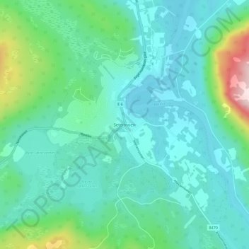
Name: Setermoen topographic map, elevation, terrain.

Location: Setermoen, Bardu, Troms og Finnmark, Norway (68.84094 18.32824 68.88094 18.36824)

Average elevation: 126 m

Minimum elevation: 57 m

Maximum elevation: 419 m

Other topographic maps

Click on a map to view its topography, its elevation and its terrain.

Senja

Norway > Troms og Finnmark

Average elevation: 122 m

Gratangen

Norway > Troms og Finnmark

Average elevation: 350 m

Hasvik

Norway > Troms og Finnmark

Average elevation: 52 m

Kvænangen

Norway > Troms og Finnmark

Average elevation: 447 m

Silda

Norway > Troms og Finnmark

Average elevation: 90 m

South Varanki

Norway > Troms og Finnmark

Average elevation: 150 m

Hersøya

Norway > Troms og Finnmark

Average elevation: 22 m

Gear up for your next adventure:

🥫Expedition Meals - Lightweight, high-calorie nutrition for long-distance hikers
🧴Sport Sunscreen Sticks - High-protection sunblock that won't run into your eyes on the trail
💧Hydration Reservoirs - Convenient water bladders for hands-free drinking on the move
🔋Solar Power Banks - Keep your GPS and phone charged during multi-day expeditions
🎒Replacement Sternum Straps - Repair parts for hiking rucksacks

As an Amazon Associate, this site earns from qualifying purchases at no extra cost to you.