
Évora topographic map
Interactive map
Click on the map to display elevation.
About this map
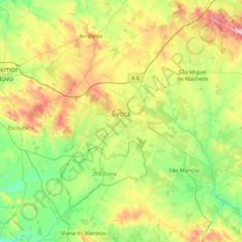
Name: Évora topographic map, elevation, terrain.
Location: Évora, Portugal (38.34068 -8.16570 38.76820 -7.55494)
Average elevation: 247 m
Minimum elevation: 112 m
Maximum elevation: 550 m
Évora (altitude 300m) is situated in Alentejo, a large region of wide plains in the south of Portugal, bordered to the North by the Tagus River and to the South by the region of Algarve. The city is 140 km (87 mi) from the capital city Lisbon, and 80 km (50 mi) from Badajoz at the Spanish border. It is the chief city of the region.
Other topographic maps
Click on a map to view its topography, its elevation and its terrain.
Cabrela
Portugal > Évora > Montemor-o-Novo
Cabrela, Montemor-o-Novo, Évora, Portugal
Average elevation: 110 m
Terena
Portugal > Évora > Terena (São Pedro)
Terena, Terena (São Pedro), Alandroal, Évora, 7250-065, Portugal
Average elevation: 191 m
Ribeira de Cabrela
Ribeira de Cabrela, Cabrela, Montemor-o-Novo, Évora, Portugal
Average elevation: 76 m
Évora Monte
Portugal > Évora > Évora Monte > Évora Monte
Évora Monte, Estremoz, Évora, Portugal
Average elevation: 325 m