Geolocate

Mountmellick topographic map

Interactive map

Click on the map to display elevation.

About this map

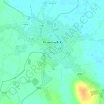
Name: Mountmellick topographic map, elevation, terrain.

Location: Mountmellick, The Municipal District of Borris-in-Ossory — Mountmellick, County Laois, Leinster, Ireland (53.10431 -7.34878 53.12559 -7.30374)

Average elevation: 76 m

Minimum elevation: 68 m

Maximum elevation: 101 m

Other topographic maps

Click on a map to view its topography, its elevation and its terrain.

Stradbally

Ireland > County Laois

Stradbally, Stradbally ED, The Municipal District of Graiguecullen — Portarlington, County Laois, Leinster, Ireland

Average elevation: 92 m

Burke's Cross

Ireland > County Laois

Burke's Cross, Lacka ED, The Municipal District of Borris-in-Ossory — Mountmellick, County Laois, Leinster, Ireland

Average elevation: 195 m

Trumra Rock

Ireland > County Laois

Trumra Rock, Trumra ED, The Municipal District of Borris-in-Ossory — Mountmellick, County Laois, Leinster, Ireland

Average elevation: 105 m

Timahoe

Ireland > County Laois

Timahoe, The Municipal District of Graiguecullen — Portarlington, County Laois, Leinster, R32 Y09T, Ireland

Average elevation: 146 m

The Municipal District of Portlaoise

Ireland > County Laois

The Municipal District of Portlaoise, County Laois, Leinster, Ireland

Average elevation: 138 m

The Municipal District of Graiguecullen — Portarlington

Ireland > County Laois

The Municipal District of Graiguecullen — Portarlington, County Laois, Leinster, Ireland

Average elevation: 113 m

Killadooley

Ireland > County Laois

Killadooley, Ballybrophy ED, The Municipal District of Borris-in-Ossory — Mountmellick, County Laois, Leinster, Ireland

Average elevation: 122 m