
The Municipal District of Portlaoise topographic map
Interactive map
Click on the map to display elevation.
About this map
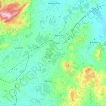
Name: The Municipal District of Portlaoise topographic map, elevation, terrain.
Average elevation: 138 m
Minimum elevation: 60 m
Maximum elevation: 513 m
Other topographic maps
Click on a map to view its topography, its elevation and its terrain.
Stradbally
Stradbally, Stradbally ED, The Municipal District of Graiguecullen — Portarlington, County Laois, Leinster, Ireland
Average elevation: 92 m
Mountmellick
Mountmellick, The Municipal District of Borris-in-Ossory — Mountmellick, County Laois, Leinster, Ireland
Average elevation: 76 m
Burke's Cross
Burke's Cross, Lacka ED, The Municipal District of Borris-in-Ossory — Mountmellick, County Laois, Leinster, Ireland
Average elevation: 195 m
Trumra Rock
Trumra Rock, Trumra ED, The Municipal District of Borris-in-Ossory — Mountmellick, County Laois, Leinster, Ireland
Average elevation: 105 m
Timahoe
Timahoe, The Municipal District of Graiguecullen — Portarlington, County Laois, Leinster, R32 Y09T, Ireland
Average elevation: 146 m
The Municipal District of Graiguecullen — Portarlington
The Municipal District of Graiguecullen — Portarlington, County Laois, Leinster, Ireland
Average elevation: 113 m
Killadooley
Killadooley, Ballybrophy ED, The Municipal District of Borris-in-Ossory — Mountmellick, County Laois, Leinster, Ireland
Average elevation: 122 m