
Lupane topographic map
Interactive map
Click on the map to display elevation.
Lupane
Lupane ( luːpɑːnɛ) District is located in the Matabeleland North Province of Zimbabwe, and it is also the Provincial Capital. The District is situated at an elevation of 976 m with a population of 198,600 inhabitants by 2019. Lupane Town is the main center of the district located 172 km from Bulawayo along the A8 Victoria Falls Road. The Government Provincial Administrative offices are located at the Town Centre. A new university near the Town has been established under the name Lupane State University, which caters for the region and beyond. The word Lupane is thought to be a Kalanga or Lozwi word.
About this map
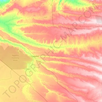
Name: Lupane topographic map, elevation, terrain.
Location: Lupane, Matabeleland North Province, Zimbabwe (-19.50360 27.34394 -18.23207 28.42569)
Average elevation: 1,042 m
Minimum elevation: 860 m
Maximum elevation: 1,218 m
Other topographic maps
Click on a map to view its topography, its elevation and its terrain.
14 Rainbow Falls
Zimbabwe > Matabeleland North Province > Hwange > Victoria Falls
Average elevation: 873 m
Batoka Gorge
Zimbabwe > Matabeleland North Province > Hwange > Victoria Falls
Average elevation: 861 m