
Aceh Jaya topographic map
Interactive map
Click on the map to display elevation.
About this map
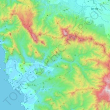
Name: Aceh Jaya topographic map, elevation, terrain.
Location: Jaya, Aceh Jaya, Aceh, Indonesia (5.06145 95.28146 5.25421 95.62739)
Average elevation: 535 m
Minimum elevation: 0 m
Maximum elevation: 2,278 m
Other topographic maps
Click on a map to view its topography, its elevation and its terrain.
Pulau Simeulue
Pulau Simeulue, Teluk Dalam, Simeulue, Aceh, Indonesia
Average elevation: 21 m