
Al Khargah City topographic map
Interactive map
Click on the map to display elevation.
About this map
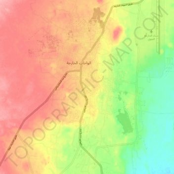
Name: Al Khargah City topographic map, elevation, terrain.
Location: Al Khargah City, New Valley, 72511, Egypt (25.39068 30.51968 25.48668 30.57375)
Average elevation: 69 m
Minimum elevation: 13 m
Maximum elevation: 112 m
Other topographic maps
Click on a map to view its topography, its elevation and its terrain.
Abu Minqar
Geologically, the area forms part of the Dakhla—Abu Minqar plateau in a shallow depression between the Kharga and Dakhla depressions, with an elevation typically of between 400 and 500 metres above sea level. The Abu Minqar Depression is often considered to be the extreme western subdivision of the Dakhla…
Average elevation: 143 m