
Spring Creek topographic map
Interactive map
Click on the map to display elevation.
About this map
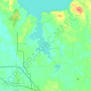
Name: Spring Creek topographic map, elevation, terrain.
Location: Spring Creek, Lawrence County, Alabama, United States (34.66136 -87.28584 34.75044 -87.24992)
Average elevation: 177 m
Minimum elevation: 163 m
Maximum elevation: 212 m
Other topographic maps
Click on a map to view its topography, its elevation and its terrain.
Wren Mountain
United States > Alabama > Lawrence County
Wren Mountain, Lawrence County, Alabama, United States
Average elevation: 230 m
Town Creek
United States > Alabama > Lawrence County
Town Creek, Lawrence County, Alabama, United States
Average elevation: 184 m
Moulton
United States > Alabama > Lawrence County
Moulton, Lawrence County, Alabama, 35650, United States
Average elevation: 198 m