
Sissach topographic map
Interactive map
Click on the map to display elevation.
About this map
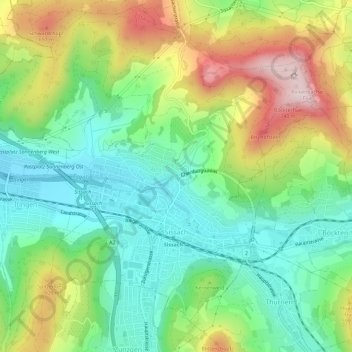
Name: Sissach topographic map, elevation, terrain.
Location: Sissach, Bezirk Sissach, Basel-Landschaft, 4450, Schweiz (47.45081 7.77677 47.48852 7.83462)
Average elevation: 492 m
Minimum elevation: 348 m
Maximum elevation: 741 m
Other topographic maps
Click on a map to view its topography, its elevation and its terrain.
Tenniken
Schweiz > Basel-Landschaft > Bezirk Sissach
Tenniken, Bezirk Sissach, Basel-Landschaft, 4456, Schweiz
Average elevation: 538 m
Läufelfingen
Schweiz > Basel-Landschaft > Bezirk Sissach
Läufelfingen, Bezirk Sissach, Basel-Landschaft, 4448, Schweiz
Average elevation: 716 m
Maisprach
Schweiz > Basel-Landschaft > Bezirk Sissach
Maisprach, Bezirk Sissach, Basel-Landschaft, 4464, Schweiz
Average elevation: 470 m
Tecknau
Schweiz > Basel-Landschaft > Bezirk Sissach
Tecknau, Bezirk Sissach, Basel-Landschaft, 4492, Schweiz
Average elevation: 556 m
Ruine Homburg
Schweiz > Basel-Landschaft > Bezirk Sissach > Läufelfingen
Ruine Homburg, Homburgweg, Läufelfingen, Bezirk Sissach, Basel-Landschaft, 4448, Schweiz
Average elevation: 642 m