
Sydney Gardens topographic map
Interactive map
Click on the map to display elevation.
About this map
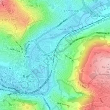
Name: Sydney Gardens topographic map, elevation, terrain.
Average elevation: 77 m
Minimum elevation: 16 m
Maximum elevation: 206 m
Other topographic maps
Click on a map to view its topography, its elevation and its terrain.
Bathwick Hill
United Kingdom > England > Bath and North East Somerset > Bath
Bathwick Hill, Bathwick, Bath, Bath and North East Somerset, West of England, England, BA2 6JY, United Kingdom
Average elevation: 93 m