Geolocate

Rhos topographic map

Click on the map to display elevation.

About this map

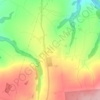
Name: Rhos topographic map, elevation, terrain.

Location: Rhos, Llangeler, Carmarthenshire, Wales, United Kingdom (51.98973 -4.36719 51.99895 -4.35123)

Average elevation: 206 m

Minimum elevation: 97 m

Maximum elevation: 309 m

Carmarthenshire trails, hiking, mountain biking, running and outdoor activities

Gear up for your next adventure:

🎿Telescopic Trekking Poles - Reduces knee strain on steep topographic descents
Insulated Travel Mugs - Keep drinks hot while surveying the landscape from a summit
📻Hand-Crank Emergency Radios - Stay updated on weather warnings in remote areas
🥤Hydration Bladders - Hands-free hydration systems for backpacks
📚UK Hiking Guidebooks - Detailed route descriptions for the Lake District, Peaks, and Highlands

As an Amazon Associate, this site earns from qualifying purchases at no extra cost to you.