
Kota Baru Santan topographic map
Interactive map
Click on the map to display elevation.
About this map
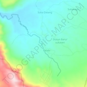
Name: Kota Baru Santan topographic map, elevation, terrain.
Location: Kota Baru Santan, Lebong Utara, Bengkulu, Indonesia (-3.18945 102.12910 -3.14945 102.16910)
Average elevation: 566 m
Minimum elevation: 466 m
Maximum elevation: 865 m
Other topographic maps
Click on a map to view its topography, its elevation and its terrain.
Talang Ulu
Indonesia > Bengkulu > Lebong Utara
Talang Ulu, Lebong Utara, Bengkulu, Indonesia
Average elevation: 433 m