
Make a donation
Gear up for your next adventure:
As an Amazon Associate, this site earns from qualifying purchases at no extra cost to you.
Buchenau topographic map
Click on the map to display elevation.
Make a donation
Gear up for your next adventure:
As an Amazon Associate, this site earns from qualifying purchases at no extra cost to you.
About this map
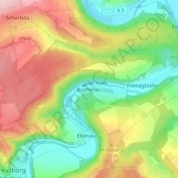
Name: Buchenau topographic map, elevation, terrain.
Average elevation: 284 m
Minimum elevation: 177 m
Maximum elevation: 422 m
Make a donation
Gear up for your next adventure:
As an Amazon Associate, this site earns from qualifying purchases at no extra cost to you.
Other topographic maps
Click on a map to view its topography, its elevation and its terrain.
Eisenach
Germany > Thuringia > Wartburgkreis
Eisenach is at the northern edge of the Thuringian Forest, at an elevation of about 220 m. The terrain is hilly, and to the south also mountainous (up to 460 m of elevation), with the central Hörsel valley crossing the town in east–west direction. The Nesse river enters the Hörsel river in Eisenach after…
Average elevation: 298 m
Eisenach
Germany > Thuringia > Wartburgkreis
Eisenach is situated at the northern edge of the Thuringian Forest, at an elevation of about 220 m. The terrain is hilly, to the south also mountainous (up to 460 m of elevation), with the central Hörsel valley crossing the town in east-western direction. The Nesse river enters the Hörsel river in Eisenach…
Average elevation: 298 m
Make a donation
Gear up for your next adventure:
As an Amazon Associate, this site earns from qualifying purchases at no extra cost to you.
Make a donation
Gear up for your next adventure:
As an Amazon Associate, this site earns from qualifying purchases at no extra cost to you.