
Bethlehem topographic map
Interactive map
Click on the map to display elevation.
About this map
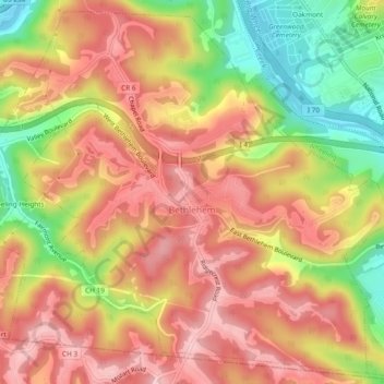
Name: Bethlehem topographic map, elevation, terrain.
Location: Bethlehem, Ohio County, West Virginia, United States (40.02863 -80.71363 40.06254 -80.66667)
Average elevation: 318 m
Minimum elevation: 197 m
Maximum elevation: 400 m
According to the United States Census Bureau, the village has a total area of 3.54 square miles (9.17 km2), all land, at an elevation of 1,243 feet (379 m).
Other topographic maps
Click on a map to view its topography, its elevation and its terrain.
Echo Point
United States > West Virginia > Ohio County > Wheeling
Echo Point, Wheeling, Ohio County, West Virginia, 26003, United States
Average elevation: 293 m
West Liberty
United States > West Virginia > Ohio County
West Liberty, Ohio County, West Virginia, United States
Average elevation: 354 m
Clearview
United States > West Virginia > Ohio County
Clearview, Ohio County, West Virginia, United States
Average elevation: 302 m
Pleasant Valley
United States > West Virginia > Ohio County > Wheeling > Pleasant Valley
Pleasant Valley, Wheeling, Ohio County, West Virginia, 26003, United States
Average elevation: 284 m
Wheeling
United States > West Virginia > Ohio County > Wheeling
Wheeling, Ohio County, West Virginia, 26003, United States
Average elevation: 326 m
Wheeling
United States > West Virginia > Ohio County
Wheeling, Ohio County, West Virginia, 26003, United States
Average elevation: 305 m