
Katerini Municipality topographic map
Interactive map
Click on the map to display elevation.
About this map
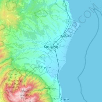
Name: Katerini Municipality topographic map, elevation, terrain.
Average elevation: 333 m
Minimum elevation: -4 m
Maximum elevation: 2,889 m
Katerini (Greek: Κατερίνη, Kateríni, pronounced [ka̠te̞ˈɾini]) is a city and municipality in northern Greece, the capital city of Pieria regional unit in Central Macedonia, Greece. It lies on the Pierian plain, between Mt. Olympus and the Thermaikos Gulf, at an altitude of 14 m. The municipal unit of Katerini has a population of 85,851 (according to the 2014 census) and it is the second most populous urban area at the Region of Macedonia after Thessaloniki. The close distance between two cities (68 km), has been beneficial for Katerini's development over recent years. Katerini is accessible from the main Thessaloniki–Athens highway GR-1/E75 (with the Katerini's South, East and North interchanges) and the Egnatia Odos to the north. It is served by Intercity, Proastiakos (Suburban Railway) and local trains on the main railway line from Athens to Thessaloniki and there is a comprehensive regional and national bus service with its hub in the city.
Other topographic maps
Click on a map to view its topography, its elevation and its terrain.
Πέλεκας
Greece > Macedonia and Thrace > Pieria Regional Unit > Katerini Municipality > Αρωνάς
Πέλεκας, Αρωνάς, Katerini Municipality, Pieria Regional Unit, Central Macedonia, Macedonia and Thrace, 601 50, Greece
Average elevation: 140 m
Τόξο
Greece > Macedonia and Thrace > Pieria Regional Unit > Katerini Municipality
Τόξο, Katerini Municipality, Pieria Regional Unit, Central Macedonia, Macedonia and Thrace, 601 50, Greece
Average elevation: 236 m
Litochoro
Greece > Macedonia and Thrace > Pieria Regional Unit
Litochoro, Dion - Olympos Municipality, Pieria Regional Unit, Central Macedonia, Macedonia and Thrace, 602 00, Greece
Average elevation: 396 m
Ράχη
Greece > Macedonia and Thrace > Pieria Regional Unit > Katerini Municipality
Ράχη, Katerini Municipality, Pieria Regional Unit, Central Macedonia, Macedonia and Thrace, 601 50, Greece
Average elevation: 202 m
Dion - Olympos Municipality
Greece > Macedonia and Thrace > Pieria Regional Unit
Dion - Olympos Municipality, Pieria Regional Unit, Central Macedonia, Macedonia and Thrace, Greece
Average elevation: 629 m
Alonia
Greece > Macedonia and Thrace > Pieria Regional Unit > Alonia
Alonia, Δήμος Πύδνας - Κολινδρού, Pieria Regional Unit, Central Macedonia, Macedonia and Thrace, 60064, Greece
Average elevation: 134 m
Peristasi
Greece > Macedonia and Thrace > Pieria Regional Unit > Katerini > Peristasi
Peristasi, Katerini, Pieria Regional Unit, Central Macedonia, Macedonia and Thrace, 601 50, Greece
Average elevation: 23 m