
Grand Coulee topographic map
Interactive map
Click on the map to display elevation.
About this map
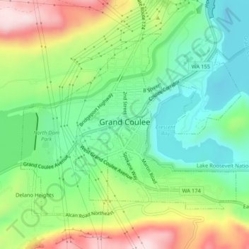
Name: Grand Coulee topographic map, elevation, terrain.
Average elevation: 502 m
Minimum elevation: 371 m
Maximum elevation: 723 m
Other topographic maps
Click on a map to view its topography, its elevation and its terrain.
Quincy
United States > Washington > Grant County
Quincy, Grant County, Washington, United States
Average elevation: 400 m
Trinidad
United States > Washington > Grant County > Trinidad
Trinidad, Grant County, Washington, United States
Average elevation: 302 m
Moses Lake
United States > Washington > Grant County
Moses Lake, Grant County, Washington, 98837, United States
Average elevation: 350 m