Make a donation
Gear up for your next adventure:
As an Amazon Associate, this site earns from qualifying purchases at no extra cost to you.
Weimar topographic map
Click on the map to display elevation.
Make a donation
Gear up for your next adventure:
As an Amazon Associate, this site earns from qualifying purchases at no extra cost to you.
Weimar
Weimar is situated within the valley of Ilm river, a tributary of Saale river on the southern border of the Thuringian Basin, a fertile agricultural area between the Harz mountains 70 km (43 mi) in the north and the Thuringian Forest 50 km (31 mi) in the southwest. The municipal terrain is hilly; the height of the city centre in Ilm valley is approximately 200 m of elevation. To the north, the terrain rises to Ettersberg, the city's backyard mountain, 482 m in height. The range of hills in the south of Weimar rises up to 370 m and is part of the Ilm Saale Plate Muschelkalk formation. The eastern, central and western parts of the municipal territory are in agricultural use, whereas the Ettersberg and some southern areas are wooded.
Make a donation
Gear up for your next adventure:
As an Amazon Associate, this site earns from qualifying purchases at no extra cost to you.
About this map
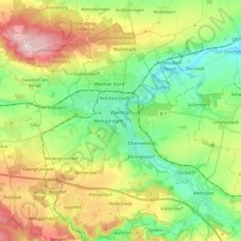
Name: Weimar topographic map, elevation, terrain.
Location: Weimar, Thuringia, Germany (50.91711 11.23491 51.03671 11.40196)
Average elevation: 299 m
Minimum elevation: 188 m
Maximum elevation: 481 m
Make a donation
Gear up for your next adventure:
As an Amazon Associate, this site earns from qualifying purchases at no extra cost to you.
Other topographic maps
Click on a map to view its topography, its elevation and its terrain.
Make a donation
Gear up for your next adventure:
As an Amazon Associate, this site earns from qualifying purchases at no extra cost to you.
Make a donation
Gear up for your next adventure:
As an Amazon Associate, this site earns from qualifying purchases at no extra cost to you.
Make a donation
Gear up for your next adventure:
As an Amazon Associate, this site earns from qualifying purchases at no extra cost to you.
Make a donation
Gear up for your next adventure:
As an Amazon Associate, this site earns from qualifying purchases at no extra cost to you.
Jena
Jena is situated in a hilly landscape in eastern Thuringia at the Saale river, between the Harz mountains 85 km (53 mi) in the north, the Thuringian Forest/Thuringian Highland 50 km (31 mi) in the southwest and the Ore Mountains, 75 km (47 mi) in the southeast. The municipal terrain is hilly with rugged slopes…
Average elevation: 289 m
Make a donation
Gear up for your next adventure:
As an Amazon Associate, this site earns from qualifying purchases at no extra cost to you.
Rotterode
Germany > Thuringia > Landkreis Schmalkalden-Meiningen > Steinbach-Hallenberg
Average elevation: 570 m
Make a donation
Gear up for your next adventure:
As an Amazon Associate, this site earns from qualifying purchases at no extra cost to you.
Make a donation
Gear up for your next adventure:
As an Amazon Associate, this site earns from qualifying purchases at no extra cost to you.
Make a donation
Gear up for your next adventure:
As an Amazon Associate, this site earns from qualifying purchases at no extra cost to you.
Thamsbrück
Germany > Thuringia > Unstrut-Hainich-Kreis > Bad Langensalza > Thamsbrück
Average elevation: 189 m
Make a donation
Gear up for your next adventure:
As an Amazon Associate, this site earns from qualifying purchases at no extra cost to you.
Make a donation
Gear up for your next adventure:
As an Amazon Associate, this site earns from qualifying purchases at no extra cost to you.
Zeutsch
Germany > Thuringia > Landkreis Saalfeld-Rudolstadt > Uhlstädt-Kirchhasel
Average elevation: 227 m
