
松戸市 topographic map
Interactive map
Click on the map to display elevation.
About this map
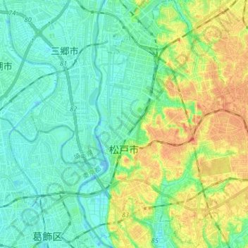
Name: 松戸市 topographic map, elevation, terrain.
Location: 松戸市, 千葉県, 日本 (35.74672 139.87939 35.84977 140.00136)
Average elevation: 13 m
Minimum elevation: -7 m
Maximum elevation: 37 m
東部地域は下総台地(海抜20-30メートル)の西端となっていて、現在では概ね住宅地が広がっているが、1960年代以前は、山林や果樹園、畑が多く見られた。標高は市域のほぼ中央に位置する常盤平駅周辺が最も高く、ここを境にして市内の河川は西に向かい東京湾へ流れる江戸川水系と、東に向かい太平洋へ注ぎ込む東の手賀沼・利根川水系に分かれている。なお、市内を流れる坂川は、北千葉導水路の一部として江戸川に流れている。
Other topographic maps
Click on a map to view its topography, its elevation and its terrain.