Geolocate

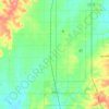
Hectorville topographic map

Click on the map to display elevation.

About this map

Name: Hectorville topographic map, elevation, terrain.

Location: Hectorville, Okmulgee County, Oklahoma, United States (35.82192 -95.94606 35.86192 -95.90606)

Average elevation: 211 m

Minimum elevation: 187 m

Maximum elevation: 270 m

Other topographic maps

Click on a map to view its topography, its elevation and its terrain.
Henryetta

United States > Oklahoma > Okmulgee County

Average elevation: 236 m

Beggs

United States > Oklahoma > Okmulgee County

Average elevation: 238 m

Gear up for your next adventure:

🔥Reusable Hand Warmers - Maintain dexterity in your fingers for precise map handling
🧥Packable Down Jackets - Lightweight warmth that compresses small in your bag
🌄Outdoor Binoculars - Compact binoculars for landscape observation
🧤Waterproof Overmitts - Extreme weather protection for hikers and mountaineers
📻Hand-Crank Emergency Radios - Stay updated on weather warnings in remote areas

As an Amazon Associate, this site earns from qualifying purchases at no extra cost to you.