
Val-de-Ruz topographic map
Interactive map
Click on the map to display elevation.
About this map
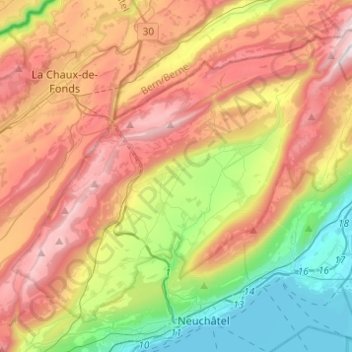
Name: Val-de-Ruz topographic map, elevation, terrain.
Location: Val-de-Ruz, Neuchâtel, Switzerland (46.98898 6.79541 47.12731 7.03996)
Average elevation: 923 m
Minimum elevation: 422 m
Maximum elevation: 1,510 m
Other topographic maps
Click on a map to view its topography, its elevation and its terrain.
La Chaux-de-Fonds
Switzerland > Neuchâtel > La Chaux-de-Fonds
La Chaux-de-Fonds, District de La Chaux-de-Fonds, Neuchâtel, Switzerland
Average elevation: 1,039 m
Saint-Blaise
Switzerland > Neuchâtel > Saint-Blaise
Saint-Blaise, Neuchâtel, 2072, Switzerland
Average elevation: 687 m