
Basse-Nendaz topographic map
Interactive map
Click on the map to display elevation.
About this map
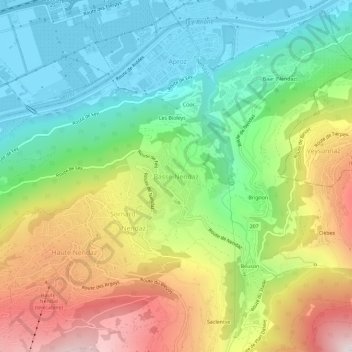
Name: Basse-Nendaz topographic map, elevation, terrain.
Location: Basse-Nendaz, Nendaz, Conthey, Valais, 1997, Suisse (46.17257 7.29208 46.21257 7.33208)
Average elevation: 959 m
Minimum elevation: 473 m
Maximum elevation: 1,753 m
Other topographic maps
Click on a map to view its topography, its elevation and its terrain.
Mayens de My
Suisse > Valais > Conthey > Conthey
Mayens de My, Conthey, Valais, 1964, Suisse
Average elevation: 1,523 m
Beuson
Suisse > Valais > Conthey > Basse-Nendaz
Beuson, Basse-Nendaz, Nendaz, Conthey, Valais, 1997, Suisse
Average elevation: 1,302 m