
Tobago topographic map
Interactive map
Click on the map to display elevation.
About this map
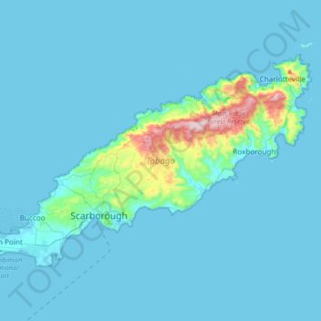
Name: Tobago topographic map, elevation, terrain.
Location: Tobago, Trinidad and Tobago (11.13412 -60.84570 11.34673 -60.51760)
Average elevation: 39 m
Minimum elevation: -1 m
Maximum elevation: 563 m
Other topographic maps
Click on a map to view its topography, its elevation and its terrain.
Port of Spain
Trinidad and Tobago > Port of Spain > Port of Spain
Some of the city lies on land reclaimed from the Gulf of Paria, the calm sheltered bay separating Trinidad from Venezuela, while other parts climb into the hills above the city. Geographically, the Port of Port of Spain is ideal for maritime traffic, providing a natural harbour on Trinidad's north-western…
Average elevation: 59 m
Saint Joseph Village
Trinidad and Tobago > San Fernando > Saint Joseph Village
Average elevation: 21 m