
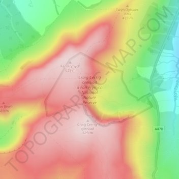
Craig Cerrig Gleisiad a Fan Frynych National Nature Reserve topographic map
Interactive map
Click on the map to display elevation.
About this map
Name: Craig Cerrig Gleisiad a Fan Frynych National Nature Reserve topographic map, elevation, terrain.
Average elevation: 473 m
Minimum elevation: 257 m
Maximum elevation: 630 m
Powys trails, hiking, mountain biking, running and outdoor activities
Other topographic maps
Click on a map to view its topography, its elevation and its terrain.
Brecon Beacons National Park
United Kingdom > Wales > Powys
Brecon Beacons National Park, officially named Bannau Brycheiniog National Park (Welsh pronunciation), is a national park in Wales. It is named after the Brecon Beacons (Welsh: Bannau Brycheiniog), the mountain range at its centre. The national park includes the highest mountain in South Wales, Pen y Fan,…
Average elevation: 270 m