
Town of Gilboa topographic map
Interactive map
Click on the map to display elevation.
About this map
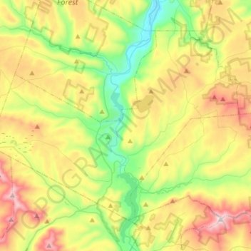
Name: Town of Gilboa topographic map, elevation, terrain.
Location: Town of Gilboa, Schoharie County, New York, United States (42.35510 -74.58933 42.50199 -74.32602)
Average elevation: 541 m
Minimum elevation: 215 m
Maximum elevation: 1,031 m
Other topographic maps
Click on a map to view its topography, its elevation and its terrain.
Town of Middleburgh
United States > New York > Schoharie County
Town of Middleburgh, Schoharie County, New York, United States
Average elevation: 406 m
Watsonville
United States > New York > Schoharie County > Watsonville
Watsonville, Town of Fulton, Schoharie County, New York, 12071, United States
Average elevation: 339 m
Petersburg Mountain
United States > New York > Schoharie County
Petersburg Mountain, Town of Fulton, Schoharie County, New York, 12187, United States
Average elevation: 604 m
Village of Cobleskill
United States > New York > Schoharie County > Town of Cobleskill
Village of Cobleskill, Town of Cobleskill, Schoharie County, New York, United States
Average elevation: 345 m