
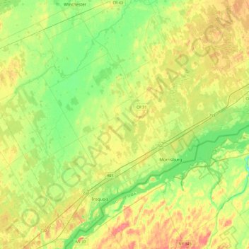
South Dundas topographic map
Interactive map
Click on the map to display elevation.
About this map
Name: South Dundas topographic map, elevation, terrain.
Average elevation: 82 m
Minimum elevation: 59 m
Maximum elevation: 112 m
Other topographic maps
Click on a map to view its topography, its elevation and its terrain.
Alexandria
Canada > Ontario > Stormont, Dundas and Glengarry Counties > North Glengarry
Average elevation: 84 m
Dalkeith
Canada > Ontario > Stormont, Dundas and Glengarry Counties > North Glengarry
Average elevation: 70 m
Moose Creek
Canada > Ontario > Stormont, Dundas and Glengarry Counties > North Stormont
Average elevation: 87 m
McLaren Island
Canada > Ontario > Stormont, Dundas and Glengarry Counties > South Stormont > Ingleside
Average elevation: 74 m
Tayside
Canada > Ontario > Stormont, Dundas and Glengarry Counties > North Stormont
Average elevation: 85 m
Winchester
Canada > Ontario > Stormont, Dundas and Glengarry Counties > North Dundas
Average elevation: 76 m
North Lunenburg
Canada > Ontario > Stormont, Dundas and Glengarry Counties > South Stormont
Average elevation: 87 m
Summerstown Station
Canada > Ontario > Stormont, Dundas and Glengarry Counties > South Glengarry
Average elevation: 54 m
South Mountain
Canada > Ontario > Stormont, Dundas and Glengarry Counties > North Dundas
Average elevation: 82 m
Finch
Canada > Ontario > Stormont, Dundas and Glengarry Counties > North Stormont
Average elevation: 83 m