Geolocate

Devine topographic map

Click on the map to display elevation.

About this map
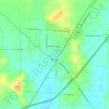
Name: Devine topographic map, elevation, terrain.

Location: Devine, Medina County, Texas, 78016, United States (29.12038 -98.94366 29.16427 -98.88385)

Average elevation: 204 m

Minimum elevation: 191 m

Maximum elevation: 230 m

Other topographic maps

Click on a map to view its topography, its elevation and its terrain.

Mico

United States > Texas > Medina County

Average elevation: 334 m

Mico

United States > Texas > Medina County

Average elevation: 334 m

Coal Mine

United States > Texas > Medina County > Lytle

Average elevation: 226 m

D'Hanis

United States > Texas > Medina County

D'Hanis is at an elevation of 883 feet (269 m) above sea level.

Average elevation: 273 m
Coal Mine

United States > Texas > Medina County > Lytle

Average elevation: 226 m

Castroville

United States > Texas > Medina County

Average elevation: 249 m

Noonan

United States > Texas > Medina County

Average elevation: 247 m

Gear up for your next adventure:

🕶️Polarized Sunglasses - Reduces glare from snow and water when reading terrain
🧤Thermal Touchscreen Gloves - Stay warm while operating your GPS or smartphone camera
🧣Fleece Neck Warmers - Extra insulation for winter topographic surveys
🚲Bikepacking Frame Bags - Storage for tools and navigation gear on long off-road rides
🌦️Portable Weather Meters - Handheld tools for monitoring weather conditions

As an Amazon Associate, this site earns from qualifying purchases at no extra cost to you.