
Hanauma Bay topographic map
Interactive map
Click on the map to display elevation.
Hanauma Bay
Approximately 3.9 million years ago, the Waiʻanae volcano created the island of Oʻahu. About 2.5 million years ago, the Koʻolau volcano breached the ocean's surface and continued to grow in elevation until about 1.7 million years ago, when it went dormant. Most of the eastern or windward portion of Oʻahu are remnants of this volcano. Most of the familiar geographic landmarks of eastern Oʻahu were created by eruptions from Koʻolau from about 500,000 to 10,000 years ago. The eastern flank of the Koʻolau volcano including the caldera slid into the sea, leaving the Koʻolau mountain range that can be seen today on the windward side of the island.
About this map
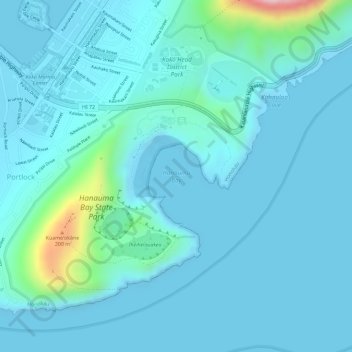
Name: Hanauma Bay topographic map, elevation, terrain.
Location: Hanauma Bay, Honolulu County, Hawaii, 96825, United States (21.26957 -157.69386 21.26967 -157.69376)
Average elevation: 32 m
Minimum elevation: -2 m
Maximum elevation: 261 m
Other topographic maps
Click on a map to view its topography, its elevation and its terrain.
Oʻahu
United States > Hawaii > Honolulu County
Oʻahu exhibits a striking and diverse topography shaped primarily by its volcanic origins and subsequent erosion. The island features a rugged landscape dominated by two prominent volcanic mountains, Koʻolau and Waiʻanae, which rise sharply from the coastline, reaching elevations of approximately 4,000…
Average elevation: 79 m
Pearl Harbor National Memorial
United States > Hawaii > Honolulu County > Waipahu
Average elevation: 9 m
Waimānalo Beach Park
United States > Hawaii > Honolulu County > East Honolulu > Waimanalo
Average elevation: 55 m
Lisianski Island
United States > Hawaii > Honolulu County
Lisianski Island (Hawaiian: Papa‘āpoho) is one of the Northwestern Hawaiian Islands, with a land area of 384.425 acres (155.571 ha) and a maximum elevation of 40 feet (12 m) above sea level. It is a low, flat sand and coral island about 905 nautical miles (1,676 km) northwest of Honolulu. The island is…
Average elevation: 1 m