
Bessemer topographic map
Click on the map to display elevation.
About this map
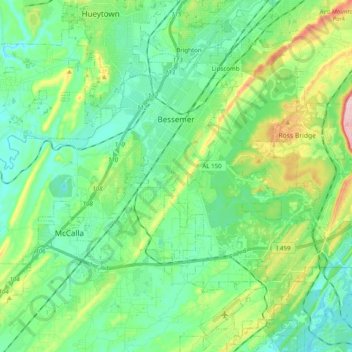
Name: Bessemer topographic map, elevation, terrain.
Location: Bessemer, Jefferson County, Alabama, United States (33.30062 -87.07055 33.44988 -86.87378)
Average elevation: 174 m
Minimum elevation: 117 m
Maximum elevation: 336 m
Other topographic maps
Click on a map to view its topography, its elevation and its terrain.
Crestline Heights
United States > Alabama > Jefferson County > Mountain Brook
Average elevation: 241 m