Geolocate

West Jefferson topographic map

Interactive map

Click on the map to display elevation.

About this map

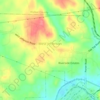
Name: West Jefferson topographic map, elevation, terrain.

Location: West Jefferson, Jefferson County, Alabama, United States (33.63824 -87.08398 33.65673 -87.05695)

Average elevation: 114 m

Minimum elevation: 79 m

Maximum elevation: 153 m

Other topographic maps

Click on a map to view its topography, its elevation and its terrain.

Birmingham

United States > Alabama > Jefferson County

Birmingham has a varied and rugged topography shaped by the nearby Appalachian foothills. The city sits at an average elevation of around 600 feet (183 meters), though it is surrounded by more dramatic terrain that rises higher to 1,000 feet (305 meters) in some areas, particularly to the south and east​.…

Average elevation: 193 m

Powderly

United States > Alabama > Jefferson County > Birmingham

Average elevation: 186 m

Birmingham

United States > Alabama > Jefferson County

Average elevation: 193 m

Oak Park

United States > Alabama > Jefferson County > Tarrant

Average elevation: 189 m

Graysville

United States > Alabama > Jefferson County

Average elevation: 138 m

Kingston

United States > Alabama > Jefferson County > Birmingham

Average elevation: 196 m

Lakewood

United States > Alabama > Jefferson County > Birmingham

Average elevation: 241 m

Homewood

United States > Alabama > Jefferson County

Average elevation: 233 m

Oak Park

United States > Alabama > Jefferson County > Tarrant

Average elevation: 189 m

Hoover

United States > Alabama > Jefferson County

Average elevation: 183 m

Hoover

United States > Alabama > Jefferson County

Average elevation: 183 m

Adger

United States > Alabama > Jefferson County

Average elevation: 153 m

Avon Park

United States > Alabama > Jefferson County > Birmingham

Average elevation: 189 m

Bendale

United States > Alabama > Jefferson County > Birmingham

Average elevation: 184 m

Leeds

United States > Alabama > Jefferson County

Average elevation: 218 m

Fultondale

United States > Alabama > Jefferson County

Due to difficult topography, for many years Fultondale was limited in its ability to grow. However, as technology improved, the ability to convert what had been difficult to unusable land for retail and commercial purposes improved. The Colonial Promenade Fultondale development was a project of Colonial…

Average elevation: 185 m

Hueytown

United States > Alabama > Jefferson County

Average elevation: 164 m

Fultondale

United States > Alabama > Jefferson County

Due to difficult topography, for many years Fultondale was limited in its ability to grow. However, as technology improved, the ability to convert what had been difficult to unusable land for retail and commercial purposes improved. The Colonial Promenade Fultondale development was a project of Colonial…

Average elevation: 185 m

Trussville

United States > Alabama > Jefferson County

Average elevation: 255 m

Brookside

United States > Alabama > Jefferson County

Average elevation: 147 m

Warrior

United States > Alabama > Jefferson County

Warrior is in the Central time zone. The elevation at the center of town is 564 feet (172 m), though it ranges from over 620 feet (190 m) north of the center to less than 300 feet (91 m) along the Locust Fork of the Black Warrior River, which forms the southern boundary of the city.

Average elevation: 141 m

Center Point

United States > Alabama > Jefferson County

Average elevation: 245 m

Cane Creek

United States > Alabama > Jefferson County > Warrior

Average elevation: 141 m

Oak Crossing

United States > Alabama > Jefferson County > Leeds

Average elevation: 228 m

Leeds

United States > Alabama > Jefferson County

Average elevation: 218 m

Moss Rock

United States > Alabama > Jefferson County > Trussville

Average elevation: 251 m

Birmingham

United States > Alabama > Jefferson County

Average elevation: 193 m

Bessemer

United States > Alabama > Jefferson County

Average elevation: 174 m

Irondale

United States > Alabama > Jefferson County

Average elevation: 231 m

Birmingham

United States > Alabama > Jefferson County

Average elevation: 193 m

Clay

United States > Alabama > Jefferson County

Average elevation: 285 m

Dolomite

United States > Alabama > Jefferson County > Birmingham

Average elevation: 176 m

Gardendale

United States > Alabama > Jefferson County

Average elevation: 176 m

Hoover

United States > Alabama > Jefferson County

Average elevation: 183 m

Oak Park

United States > Alabama > Jefferson County > Tarrant

Average elevation: 189 m

Ayres

United States > Alabama > Jefferson County > Clay

Average elevation: 319 m