
Leeds topographic map
Click on the map to display elevation.
About this map
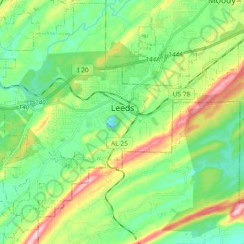
Name: Leeds topographic map, elevation, terrain.
Location: Leeds, Jefferson County, Alabama, 35094, United States (33.48573 -86.62662 33.58945 -86.49893)
Average elevation: 218 m
Minimum elevation: 143 m
Maximum elevation: 378 m
Other topographic maps
Click on a map to view its topography, its elevation and its terrain.
Crestline Heights
United States > Alabama > Jefferson County > Mountain Brook
Average elevation: 241 m