
Town of Durham topographic map
Interactive map
Click on the map to display elevation.
About this map
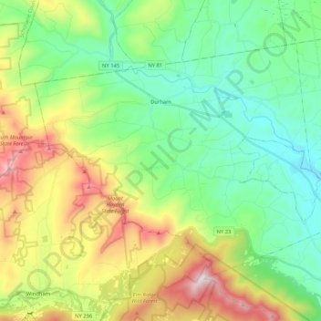
Name: Town of Durham topographic map, elevation, terrain.
Location: Town of Durham, Greene County, New York, United States (42.31491 -74.25427 42.42755 -74.04567)
Average elevation: 429 m
Minimum elevation: 129 m
Maximum elevation: 1,057 m
Other topographic maps
Click on a map to view its topography, its elevation and its terrain.
Platte Clove
United States > New York > Greene County > Town of Hunter > Platte Clove Bruderhof
Average elevation: 575 m
Kaaterskill High Peak
United States > New York > Greene County > Town of Hunter
Average elevation: 850 m
West Coxsackie
United States > New York > Greene County > Village of Coxsackie
Average elevation: 33 m