
Kipkarren topographic map
Interactive map
Click on the map to display elevation.
About this map
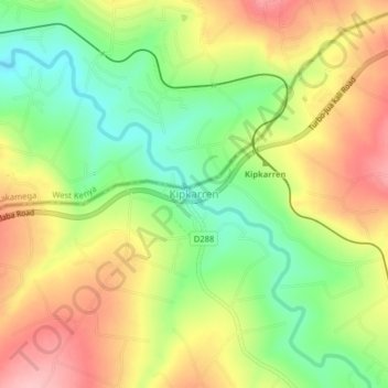
Name: Kipkarren topographic map, elevation, terrain.
Location: Kipkarren, Uasin Gishu County, Kenya (0.58775 34.94453 0.62775 34.98453)
Average elevation: 1,699 m
Minimum elevation: 1,628 m
Maximum elevation: 1,773 m
Other topographic maps
Click on a map to view its topography, its elevation and its terrain.
Kiplombe ward
Kenya > Uasin Gishu County > Turbo
Kiplombe ward, Turbo, Uasin Gishu County, Rift Valley, Kenya
Average elevation: 2,033 m
Turbo
Turbo, Uasin Gishu County, Rift Valley, Kenya
Average elevation: 1,908 m
Racecourse ward
Kenya > Uasin Gishu County > Kesses
Racecourse ward, Kesses, Uasin Gishu County, Rift Valley, Kenya
Average elevation: 2,129 m
Strawberg
Kenya > Uasin Gishu County > Ainabkoi > Kaptagat ward
Strawberg, Kaptagat ward, Ainabkoi, Uasin Gishu County, Rift Valley, Kenya
Average elevation: 2,304 m
Eldoret
Kenya > Uasin Gishu County > Moiben
Eldoret, Kimumu ward, Moiben, Uasin Gishu County, Rift Valley, 30100, Kenya
Average elevation: 2,093 m
Kipkabus
Kenya > Uasin Gishu County > Kipkabus
Kipkabus, Uasin Gishu County, Kenya
Average elevation: 2,495 m