
Ottenhofen topographic map
Interactive map
Click on the map to display elevation.
About this map
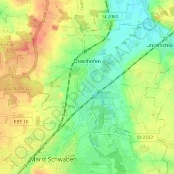
Name: Ottenhofen topographic map, elevation, terrain.
Average elevation: 507 m
Minimum elevation: 482 m
Maximum elevation: 536 m
Other topographic maps
Click on a map to view its topography, its elevation and its terrain.
Lengdorf
Duitsland > Beieren > Landkreis Erding
Lengdorf, Landkreis Erding, Beieren, 84435, Duitsland
Average elevation: 500 m
Eittingermoos
Duitsland > Beieren > Landkreis Erding
Eittingermoos, Eitting, Oberding (VGem), Landkreis Erding, Beieren, 85417, Duitsland
Average elevation: 436 m
Isen
Duitsland > Beieren > Landkreis Erding
Isen, Landkreis Erding, Beieren, 84424, Duitsland
Average elevation: 563 m