
Lengdorf topographic map
Interactive map
Click on the map to display elevation.
About this map
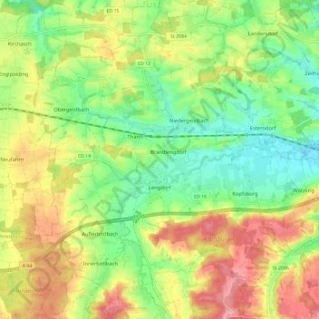
Name: Lengdorf topographic map, elevation, terrain.
Location: Lengdorf, Landkreis Erding, Beieren, 84435, Duitsland (48.22241 12.00454 48.29919 12.09908)
Average elevation: 500 m
Minimum elevation: 447 m
Maximum elevation: 568 m
Other topographic maps
Click on a map to view its topography, its elevation and its terrain.
Eittingermoos
Duitsland > Beieren > Landkreis Erding
Eittingermoos, Eitting, Oberding (VGem), Landkreis Erding, Beieren, 85417, Duitsland
Average elevation: 436 m
Isen
Duitsland > Beieren > Landkreis Erding
Isen, Landkreis Erding, Beieren, 84424, Duitsland
Average elevation: 563 m
Ottenhofen
Duitsland > Beieren > Landkreis Erding
Ottenhofen, Oberneuching (VGem), Landkreis Erding, Beieren, Duitsland
Average elevation: 507 m