Geolocate

Kailua topographic map

Click on the map to display elevation.

About this map

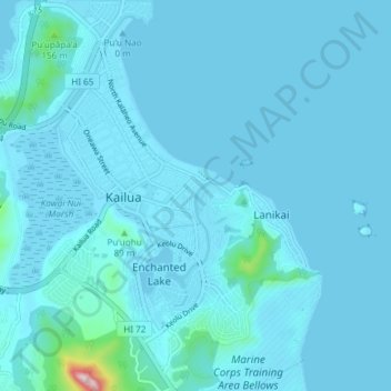
Name: Kailua topographic map, elevation, terrain.

Location: Kailua, Honolulu County, Hawaii, United States (21.35922 -157.76576 21.42857 -157.69629)

Average elevation: 34 m

Minimum elevation: -1 m

Maximum elevation: 428 m

Other topographic maps

Click on a map to view its topography, its elevation and its terrain.

‘Āhuimanu

United States > Hawaii > Honolulu County > Kailua

Average elevation: 96 m

Gear up for your next adventure:

🧢Hiking Hats - Sun and weather protection for outdoor walks
🧥Softshell Jackets - Breathable jackets for active outdoor use
🔦Outdoor Torches - Reliable torches for night navigation
🧺Microfibre Travel Towels - Fast-drying and compact towels for wild swimming and camping
GPS Outdoor Watches - Watches with GPS tracking for hiking and exploration

As an Amazon Associate, this site earns from qualifying purchases at no extra cost to you.