Geolocate

Stockbridge topographic map

Click on the map to display elevation.

About this map

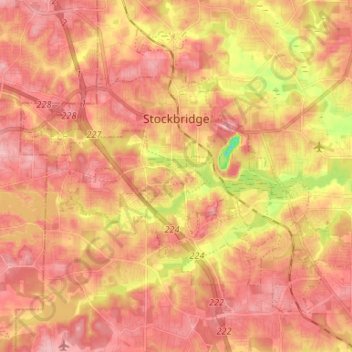
Name: Stockbridge topographic map, elevation, terrain.

Location: Stockbridge, Henry County, Georgia, United States (33.47925 -84.29218 33.57271 -84.15969)

Average elevation: 243 m

Minimum elevation: 160 m

Maximum elevation: 283 m

Other topographic maps

Click on a map to view its topography, its elevation and its terrain.

Peeksville

United States > Georgia > Henry County

Average elevation: 197 m

Fortson

United States > Georgia > Henry County > Hampton

Average elevation: 259 m

Bowden

United States > Georgia > Henry County

Average elevation: 253 m

Union

United States > Georgia > Henry County

Average elevation: 215 m

Ola

United States > Georgia > Henry County

Average elevation: 230 m

Gear up for your next adventure:

📱Phone Mounts for Hiking - Secure mounts to carry your phone on trails
🧥Waterproof Hiking Jackets - Rain protection for walking in all weather conditions
🧤Thermal Touchscreen Gloves - Stay warm while operating your GPS or smartphone camera
🧦Hiking Socks - Breathable socks designed to prevent blisters on long walks
Lightweight Solo Tents - Backpacking tents designed for wild camping in the UK highlands

As an Amazon Associate, this site earns from qualifying purchases at no extra cost to you.