Geolocate

Union topographic map

Click on the map to display elevation.

About this map

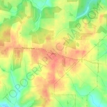
Name: Union topographic map, elevation, terrain.

Location: Union, Henry County, Georgia, United States (33.39512 -84.00297 33.43512 -83.96297)

Average elevation: 215 m

Minimum elevation: 182 m

Maximum elevation: 238 m

Other topographic maps

Click on a map to view its topography, its elevation and its terrain.

Locust Grove

United States > Georgia > Henry County

Average elevation: 230 m

Hampton

United States > Georgia > Henry County

Average elevation: 259 m

McDonough

United States > Georgia > Henry County

Average elevation: 249 m

Stockbridge

United States > Georgia > Henry County

Average elevation: 243 m

Heron Bay

United States > Georgia > Henry County

Average elevation: 237 m

Stockbridge

United States > Georgia > Henry County

Average elevation: 243 m

Hampton

United States > Georgia > Henry County

Average elevation: 259 m

McDonough

United States > Georgia > Henry County

Average elevation: 249 m

Gear up for your next adventure:

📦Dry Bags - Waterproof bags to protect gear from rain
🗺️Scratch-off Peak Maps - Track your progress climbing Munros or Wainwrights
🔋Solar Chargers - Eco-friendly charging solutions for outdoor use
🦯Walking Poles - Supportive poles for long-distance walking
🍳Camping Stoves - Compact stoves for outdoor cooking

As an Amazon Associate, this site earns from qualifying purchases at no extra cost to you.