
Laji Shan topographic map
Interactive map
Click on the map to display elevation.
About this map
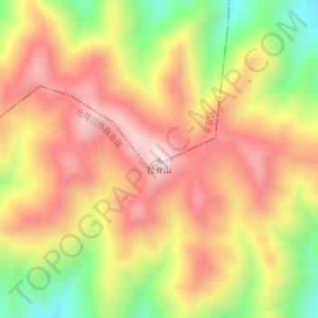
Name: Laji Shan topographic map, elevation, terrain.
Location: Laji Shan, Ping'an District, Haidong, Qinghai, China (36.26093 102.01936 36.26103 102.01946)
Average elevation: 3,493 m
Minimum elevation: 3,196 m
Maximum elevation: 3,719 m
Other topographic maps
Click on a map to view its topography, its elevation and its terrain.
1m Solar Telescope at 4000m elevation platform, NAOC
China > Qinghai > Mangnai City > Lenghu
Average elevation: 3,926 m
Yushu
With elevations above 3,600 metres (12,000 ft), the prefecture has a harsh climate, with long, cold winters, and short, rainy, and cool to warm summers. Specifically, in the Köppen system, the prefecture ranges from the alpine variation of the subarctic climate (Köppen Dwc), to a full alpine climate (Köppen…
Average elevation: 4,472 m
Qumarlêb County
With an elevation of around 4,200 metres (14,000 ft), Qumarlêb County has an alpine climate (Köppen ETH), with long, very cold winters, and short, cool and rainy summers. Average low temperatures are below freezing from mid September to late May; however, due to the wide diurnal temperature variation,…
Average elevation: 4,505 m