
Elliot Lake topographic map
Click on the map to display elevation.
About this map
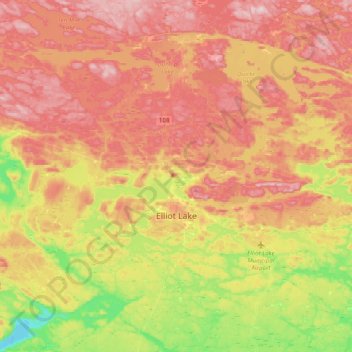
Name: Elliot Lake topographic map, elevation, terrain.
Average elevation: 342 m
Minimum elevation: 182 m
Maximum elevation: 480 m
Other topographic maps
Click on a map to view its topography, its elevation and its terrain.
Montreal River Harbour
Canada > Ontario > Algoma District > Unorganized North Algoma
Average elevation: 212 m
Lucille Lake;Wood Creek
Canada > Ontario > Algoma District > Unorganized North Algoma
Average elevation: 441 m
Echo River
Canada > Ontario > Algoma District > Macdonald, Meredith and Aberdeen Additional Township
Average elevation: 196 m
Hornepayne
Canada > Ontario > Algoma District > Hornepayne Township > Hornepayne
Average elevation: 343 m
Ogidaki Mountain
Canada > Ontario > Algoma District > Unorganized North Algoma
Average elevation: 556 m
Montreal Island
Canada > Ontario > Algoma District > Unorganized North Algoma
Average elevation: 190 m
Dog Lake Narrows
Canada > Ontario > Algoma District > Unorganized North Algoma > Missanabie
Average elevation: 335 m
Missinaibi Provincial Park
Canada > Ontario > Algoma District > Unorganized North Algoma
Average elevation: 351 m
Dog Lake Narrows
Canada > Ontario > Algoma District > Unorganized North Algoma > Missanabie
Average elevation: 335 m
Alligator Point
Canada > Ontario > Algoma District > Unorganized North Algoma
Average elevation: 319 m
The Three Sisters
Canada > Ontario > Algoma District > The North Shore Township
Average elevation: 241 m
The Three Sisters
Canada > Ontario > Algoma District > The North Shore Township
Average elevation: 241 m
The Three Sisters
Canada > Ontario > Algoma District > The North Shore Township
Average elevation: 241 m