
Kindu topographic map
Interactive map
Click on the map to display elevation.
About this map
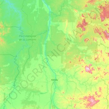
Name: Kindu topographic map, elevation, terrain.
Location: Kindu, Maniema, Democratic Republic of the Congo (-3.37547 24.47079 -1.40375 26.94059)
Average elevation: 530 m
Minimum elevation: 416 m
Maximum elevation: 1,190 m
Other topographic maps
Click on a map to view its topography, its elevation and its terrain.
Region
Democratic Republic of the Congo > Maniema > Kibombo
Region, Kibombo, Maniema, Democratic Republic of the Congo
Average elevation: 505 m
Kampene
Democratic Republic of the Congo > Maniema > Pangi
Kampene, Pangi, Maniema, Democratic Republic of the Congo
Average elevation: 684 m
Kasuku
Democratic Republic of the Congo > Maniema
Kasuku, Maniema, Democratic Republic of the Congo
Average elevation: 494 m
Fataki
Democratic Republic of the Congo > Maniema > Fataki
Fataki, Kabambare, Maniema, Democratic Republic of the Congo
Average elevation: 643 m