
City of Yonkers topographic map
Interactive map
Click on the map to display elevation.
About this map
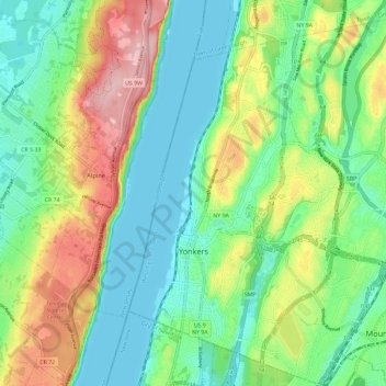
Name: City of Yonkers topographic map, elevation, terrain.
Location: City of Yonkers, Westchester County, New York, United States (40.90045 -73.91835 40.98834 -73.81042)
Average elevation: 58 m
Minimum elevation: 0 m
Maximum elevation: 172 m
Other topographic maps
Click on a map to view its topography, its elevation and its terrain.
Buckhout Corners
United States > New York > Westchester County > Village of Briarcliff Manor
Average elevation: 112 m
Mohegan Heights
United States > New York > Westchester County > City of Yonkers
Average elevation: 58 m
Lake Katonah
United States > New York > Westchester County > Town of Lewisboro
Average elevation: 127 m
South Ridge
United States > New York > Westchester County > Village of Rye Brook
Average elevation: 37 m
Murdock Woods
United States > New York > Westchester County > Town of Mamaroneck
Average elevation: 46 m
Turkey Mountain
United States > New York > Westchester County > Town of Yorktown
Average elevation: 142 m
Sleepy Hollow Manor
United States > New York > Westchester County > Village of Sleepy Hollow
Average elevation: 41 m
Furnace Woods
United States > New York > Westchester County > Town of Cortlandt
Average elevation: 116 m
Salem Center
United States > New York > Westchester County > Town of North Salem
Average elevation: 147 m
Isle of San Souci
United States > New York > Westchester County > City of New Rochelle
Average elevation: 7 m
Van Cortlandtville
United States > New York > Westchester County > Town of Cortlandt
Average elevation: 80 m
Getty Square
United States > New York > Westchester County > City of Yonkers > Ludlow
Average elevation: 31 m
South Salem
United States > New York > Westchester County > Town of Lewisboro
Average elevation: 174 m
Wykagyl Park
United States > New York > Westchester County > City of New Rochelle
Average elevation: 41 m
Murray Hill
United States > New York > Westchester County > Village of Scarsdale
Average elevation: 79 m
Sun Haven
United States > New York > Westchester County > City of New Rochelle
Average elevation: 20 m
West Mount Vernon
United States > New York > Westchester County > City of Mount Vernon
Average elevation: 49 m
Park Hill
United States > New York > Westchester County > City of Yonkers > Park Hill
Average elevation: 43 m
Vista
United States > New York > Westchester County > Town of Lewisboro > Vista
Average elevation: 154 m
Bedford Hills
United States > New York > Westchester County > Town of Bedford > Bedford Hills
Average elevation: 114 m
Purdys Grove
United States > New York > Westchester County > Village of Port Chester
Average elevation: 14 m