
Dhodra topographic map
Interactive map
Click on the map to display elevation.
About this map
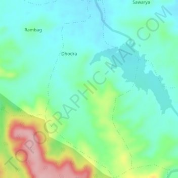
Name: Dhodra topographic map, elevation, terrain.
Location: Dhodra, Dharni, Amravati, Maharashtra, India (21.40341 76.88876 21.43527 76.90687)
Average elevation: 404 m
Minimum elevation: 360 m
Maximum elevation: 517 m
Other topographic maps
Click on a map to view its topography, its elevation and its terrain.
Kotha
India > Maharashtra > Dharni
Kotha, Dharni, Amravati, Maharashtra, India
Average elevation: 409 m