
Municipal Unit of Epidavros topographic map
Interactive map
Click on the map to display elevation.
About this map
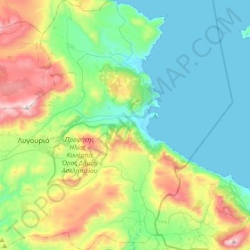
Name: Municipal Unit of Epidavros topographic map, elevation, terrain.
Average elevation: 309 m
Minimum elevation: 0 m
Maximum elevation: 1,130 m
Other topographic maps
Click on a map to view its topography, its elevation and its terrain.
Ermioni
Greece > Peloponnese, Western Greece and the Ionian > Argolis Regional Unit > Municipal Unit of Ermioni
Average elevation: 55 m
Drepano
Greece > Peloponnese, Western Greece and the Ionian > Argolis Regional Unit > Municipal Unit of Asini
Average elevation: 36 m
Artemisio
Greece > Peloponnese, Western Greece and the Ionian > Argolis Regional Unit > Municipal Unit of Lyrkeia
Average elevation: 978 m
Farmakas
Greece > Peloponnese, Western Greece and the Ionian > Argolis Regional Unit > Municipal Unit of Alea
Average elevation: 1,279 m
Δορούφι Κοιλάδος
Greece > Peloponnese, Western Greece and the Ionian > Argolis Regional Unit > Municipal Unit of Kranidi
Average elevation: 30 m
Petrothalassa
Greece > Peloponnese, Western Greece and the Ionian > Argolis Regional Unit > Municipal Unit of Kranidi
Average elevation: 24 m
Portocheli
Greece > Peloponnese, Western Greece and the Ionian > Argolis Regional Unit > Municipal Unit of Kranidi
Average elevation: 19 m
Pyrgella
Greece > Peloponnese, Western Greece and the Ionian > Argolis Regional Unit > Municipal Unit of Argos
Average elevation: 12 m
Argoliko
Greece > Peloponnese, Western Greece and the Ionian > Argolis Regional Unit > Municipal Unit of Midea
Average elevation: 17 m
Kranidi
Greece > Peloponnese, Western Greece and the Ionian > Argolis Regional Unit > Municipal Unit of Kranidi
Average elevation: 77 m
Nea Kios
Greece > Peloponnese, Western Greece and the Ionian > Argolis Regional Unit > Municipal Unit of Nea Kios > Nea Kios
Average elevation: 9 m
Asini Beach
Greece > Peloponnese, Western Greece and the Ionian > Argolis Regional Unit > Municipal Unit of Asini > Asini Beach
Average elevation: 14 m