
Ashtead Common topographic map
Interactive map
Click on the map to display elevation.
About this map
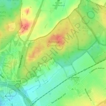
Name: Ashtead Common topographic map, elevation, terrain.
Average elevation: 60 m
Minimum elevation: 36 m
Maximum elevation: 88 m
Other topographic maps
Click on a map to view its topography, its elevation and its terrain.
Redlands Wood
United Kingdom > England > Mole Valley > Coldharbour
Redlands Wood, Coldharbour, Mole Valley, Surrey, South East England, England, RH5 6HN, United Kingdom
Average elevation: 134 m
Little Bookham
United Kingdom > England > Mole Valley > Little Bookham
Little Bookham, Mole Valley, Surrey, South East England, England, KT23 4EF, United Kingdom
Average elevation: 76 m
Capel
United Kingdom > England > Mole Valley > Capel
Capel, Mole Valley, Surrey, South East England, England, RH5 5LQ, United Kingdom
Average elevation: 91 m
Headley
United Kingdom > England > Mole Valley > Headley
Headley, Mole Valley, Surrey, South East, England, KT18 6PZ, United Kingdom
Average elevation: 149 m
Friday Street
United Kingdom > England > Mole Valley > Friday Street
Friday Street, Mole Valley, Surrey, South East, England, RH5 6JR, United Kingdom
Average elevation: 170 m