Geolocate

Howe topographic map

Click on the map to display elevation.

About this map

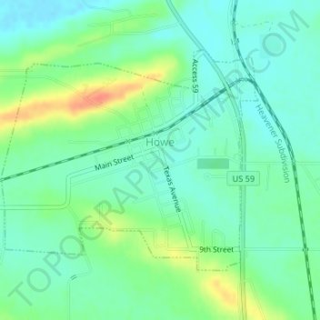
Name: Howe topographic map, elevation, terrain.

Location: Howe, LeFlore County, Oklahoma, 74940, United States (34.94036 -94.65352 34.95901 -94.62705)

Average elevation: 155 m

Minimum elevation: 140 m

Maximum elevation: 188 m

Other topographic maps

Click on a map to view its topography, its elevation and its terrain.

Cedar Knobb

United States > Oklahoma > LeFlore County > Pocola

Average elevation: 150 m

High Top

United States > Oklahoma > LeFlore County

Average elevation: 443 m

Hodgen

United States > Oklahoma > LeFlore County

Average elevation: 166 m

Page

United States > Oklahoma > LeFlore County

Average elevation: 388 m

Leflore

United States > Oklahoma > LeFlore County > Le Flore

Average elevation: 175 m

Goats Bluff

United States > Oklahoma > LeFlore County

Average elevation: 179 m

Gear up for your next adventure:

🔦Waterproof LED Headlamps - Hands-free lighting for evening treks and emergency navigation
🩹Hiking First Aid Kits - Compact medical kits tailored for trail injuries and emergencies
🧦Hiking Socks - Breathable socks designed to prevent blisters on long walks
👕Merino Base Layers - Natural temperature regulation for cold weather hiking and camping
🧥Packable Down Jackets - Lightweight warmth that compresses small in your bag

As an Amazon Associate, this site earns from qualifying purchases at no extra cost to you.