Geolocate

Pecos topographic map

Click on the map to display elevation.

About this map

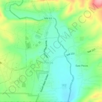
Name: Pecos topographic map, elevation, terrain.

Location: Pecos, San Miguel County, New Mexico, 87552, United States (35.56354 -105.69275 35.59196 -105.66692)

Average elevation: 2,131 m

Minimum elevation: 2,085 m

Maximum elevation: 2,221 m

Other topographic maps

Click on a map to view its topography, its elevation and its terrain.

Rociada

United States > New Mexico > San Miguel County

Average elevation: 2,350 m

Villanueva

United States > New Mexico > San Miguel County

Average elevation: 1,852 m

Chaperito

United States > New Mexico > San Miguel County

Average elevation: 1,665 m

Rowe

United States > New Mexico > San Miguel County

Average elevation: 2,138 m

Geronimo

United States > New Mexico > San Miguel County

Average elevation: 2,716 m

Tierra Monte

United States > New Mexico > San Miguel County

Average elevation: 2,307 m

Sabinoso

United States > New Mexico > San Miguel County

Average elevation: 1,481 m

Gear up for your next adventure:

🧢Waterproof Hiking Hats - Keep the rain off your face while studying topographic maps
🗺️Scratch-off Peak Maps - Track your progress climbing Munros or Wainwrights
🧢Hiking Hats - Sun and weather protection for outdoor walks
🧼Camping Hygiene Kits - Compact hygiene essentials for outdoor stays
Camping Shelters - Emergency and lightweight shelters for outdoor use

As an Amazon Associate, this site earns from qualifying purchases at no extra cost to you.