Geolocate

Rowe topographic map

Click on the map to display elevation.

About this map

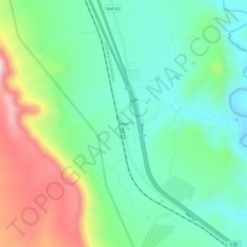
Name: Rowe topographic map, elevation, terrain.

Location: Rowe, San Miguel County, New Mexico, 87562, United States (35.47158 -105.69525 35.51158 -105.65525)

Average elevation: 2,138 m

Minimum elevation: 2,013 m

Maximum elevation: 2,407 m

Other topographic maps

Click on a map to view its topography, its elevation and its terrain.

Pecos

United States > New Mexico > San Miguel County

Average elevation: 2,131 m

Las Vegas

United States > New Mexico > San Miguel County

Average elevation: 1,994 m

Las Vegas

United States > New Mexico > San Miguel County

Average elevation: 1,994 m

Gear up for your next adventure:

Insulated Travel Mugs - Keep drinks hot while surveying the landscape from a summit
🧷Tenacious Repair Tape - Instant fix for torn tents, jackets, or dry bags
🥫Expedition Meals - Lightweight, high-calorie nutrition for long-distance hikers
🌦️Portable Weather Meters - Handheld tools for monitoring weather conditions
👟Heavy Duty Boot Laces - Always carry a spare for your hiking footwear

As an Amazon Associate, this site earns from qualifying purchases at no extra cost to you.