
Make a donation
Gear up for your next adventure:
As an Amazon Associate, this site earns from qualifying purchases at no extra cost to you.
Chico Creek topographic map
Click on the map to display elevation.
Make a donation
Gear up for your next adventure:
As an Amazon Associate, this site earns from qualifying purchases at no extra cost to you.
About this map
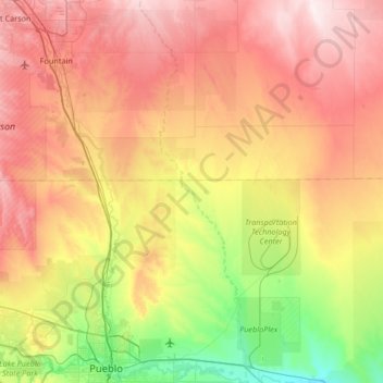
Name: Chico Creek topographic map, elevation, terrain.
Location: Chico Creek, Pueblo County, Colorado, United States (38.24306 -104.55585 38.76389 -104.36680)
Average elevation: 1,608 m
Minimum elevation: 1,356 m
Maximum elevation: 1,902 m
Make a donation
Gear up for your next adventure:
As an Amazon Associate, this site earns from qualifying purchases at no extra cost to you.
Other topographic maps
Click on a map to view its topography, its elevation and its terrain.
Make a donation
Gear up for your next adventure:
As an Amazon Associate, this site earns from qualifying purchases at no extra cost to you.
Rye
United States > Colorado > Pueblo County
Rye has a subtropical highland climate (Köppen Cfb), a climate type usually associated with maritime regions, but is also found in high elevation areas in which summer temperatures are moderated by altitude. Precipitation exceeds that of semi-arid places, and average winter temperatures exceed freezing (O°C,…
Average elevation: 2,090 m